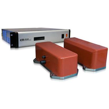
ROV载多波束测深仪EM2040

应用
• 绘制港口、内陆水道和运输通道的临界富裕水深
• 水下基础设施检测
• 检测和绘制海底杂物及其他水下物体
• 与水下建造或挖掘工作有关的详细调查
• Mapping of harbours, inland waterways and shipping channels with critical keel clearance
• Inspection of underwater infrastructure
• Detection and mapping of debris and other underwater objects
• Detailed surveys related to underwater construction work or dredging
特点
• 高分辨率&宽频率范围
• 稳定的侧倾,俯仰和偏航
• 近场聚焦 -包括发射和接收
• 脉冲长度短、带宽大
• 水柱显示和海底图像
• 易于安装
• High resolution & Wide frequency range
• Roll, pitch and yaw stabilisation
• Nearfield focusing - both on transmit and receive
• Short pulse lengths, large bandwidth
• Water column display& Seabed image
• Easy to install
技术参数
频率范围:200 – 400 kHz
额定深度:6000米
最大ping率:50 Hz
扫宽:至140°(单声呐探头)至200°(双声呐探头)
距离分辨率:距离的0.2%
波束Roll/Pitch/Yaw稳定:具备,±15°/±10°/±10°
模块化侧扫浅剖系统2200M

应用
• 地质灾害调查
• 地质/地球物理调查
• 被埋管线和电缆位置
• 路由调查
• 考古调查
• 搜索和回收
• Geo-hazard surveys
• Geological/geophysical surveys
• Buried pipeline and cable location
• Route surveys
• Archeological surveys
• Search and recovery
特点
• High Resolution高分辨率
• Full Spectrum chirp side scan sonar 全谱chirp侧扫声纳
• Full Spectrum chirp sub-bottom profiler 全谱chirp浅地层剖面仪
• Completely autonomous operation 完全自主操作
• Controllable from AUV or acoustic link 可控AUV或声学链接
技术参数
额定深度:6000米
侧扫声纳频率:75 & 120 kHz、75 & 410 kHz、120 & 410 kHz
浅地层剖面频带:1-6 kHz 2-16 kHz 4-24 kHz
TSS440

应用
• 海管和电缆的检测和跟踪
• Subsea Pipe & Cable detection and tracking
特点
• 电磁脉冲感应技术提供精确的测量信息
• 设备校准耗时短
• 易于操作、安装和维护简单
• 全方位整合的系统(高度计、备件、技术文档)
• Pulse induction technology allows accurate survey information
• No time-consuming vehicle calibrations required
• Easy to operate and Simple to install and service
• Fully integrated system with altimeter, spares and manual
技术参数
声音
类型:500 kHz 宽带换能器
范围:0.1m – 100m
精度:1mm
分辨率:±3°
压力
类型:温度补偿压阻
范围:10, 30, 100, 300 or 600 Bar
精度:±0.01% FS
分辨率:0.001% FS